Skip to main content
The Interstate 11 (I-11) Tier 1 Environmental Impact Statement (EIS) is following a process outlined by the National Environmental Policy Act (NEPA), which is illustrated in the EIS Process graphic below. The process is designed to ensure that reasonable transportation alternatives are considered, community input and involvement play a key role, and the environmental and community effects are fully disclosed.
A Notice of Intent (NOI) to prepare a Tier 1 EIS was published in the Federal Register on May 20, 2016. The publication of the NOI represents the official start of the NEPA process. General information regarding the proposed action was shared, along with notification of the scoping process and related meetings and input opportunities. As part of the NOI, the Federal Highway Administration (FHWA) and the Arizona Department of Transportation (ADOT) invited all interested individuals, organizations, public agencies, stakeholders and Native American tribes to comment on the scope of the Tier 1 EIS, including the Purpose and Need, alternatives to be studied, impacts to be evaluated, and evaluation methods to be used. The formal scoping period spanned 45 days from the publication of the NOI through July 8, 2016.
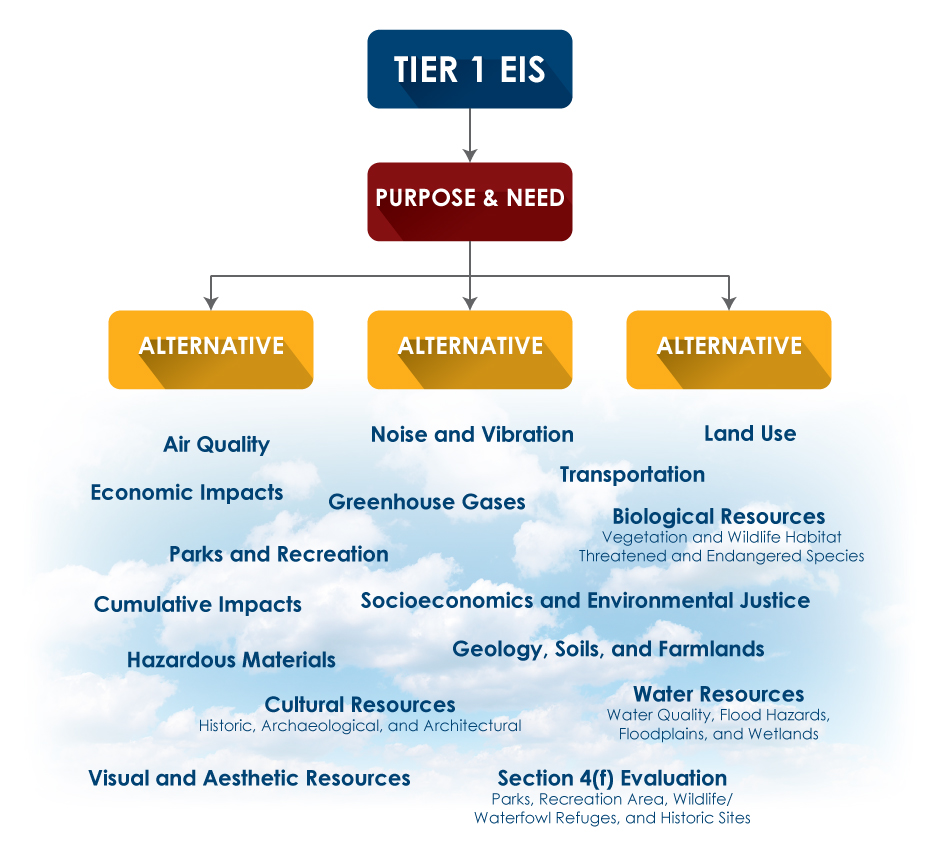
The Purpose and Need Memorandum provides background information on the evolution and planning context of the Interstate 11 corridor. It also presents the overall purpose of the I-11 corridor and outlines the factors that contribute to the need for a transportation facility within the corridor study area. The Purpose and Need is a fundamental part of the NEPA process and provides the basis for identifying, evaluating and screening corridor alternatives. It is a key component in selecting a Preferred Corridor Alternative or the No Build Alternative for I-11.
The Public Outreach and Agency Coordination Plan identifies the outreach efforts that FHWA and ADOT will undertake during the environmental review process for the Tier 1 EIS. A key focus of the plan is to facilitate an understanding with the public, tribal governments and governmental agencies regarding the study process, key milestones and decision points.
Potential issues, opportunities and concerns were solicited from various agencies, the community and others to understand the scope of topics to address during the study. Scoping activities included nine agency and public meetings across the I-11 study area, combined with an online survey and solicitation of comments via mail, email and telephone for those unable to attend the scoping meetings in person. The online survey requested the same information as the comment form distributed at the meetings. Comments were welcomed at any point in the process, but only those submitted through the end of the scoping period (July 8, 2016) were integrated into the Scoping Summary Report as formal documentation of community issues, opportunities and concerns.
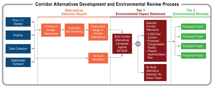
Following scoping, a wide range of corridor alternatives were developed. Various corridor options were screened using criteria consisting of multiple quantitative and qualitative measures that correspond with the Purpose and Need; public, agency and tribal input; as well as additional planning-related factors, such as potential impacts to sensitive environmental resources. The screening enabled FHWA and ADOT to refine and further consider corridor alternatives that best meet the overall Purpose and Need of the I-11 Corridor, as well as eliminate corridor options that do not adequately meet the Purpose and Need. The screening process yielded a reasonable range of corridor alternatives, along with a No Build Alternative to advance into the Tier 1 EIS phase for more detailed study. The Alternatives Selection Report documents the alternatives evaluation process and results.
The Agency and Public Information Meeting Summary Report summarizes the methods, meetings and materials used to solicit feedback, as well as the comments and input received from agencies, tribal governments and the public during the comment period from April 28, 2017 to June 2, 2017. This report, in combination with the January 2017 Scoping Summary Report, documents the public input to the alternatives development and screening process.
The Draft Tier 1 EIS is an official report issued during the NEPA process that documents the detailed analysis of the corridor alternatives. The results of this analysis identify a 2,000- foot-wide Recommended Corridor Alternative.
In the Draft Tier 1 EIS, the Build Corridor Alternatives are equally compared against a No Build Alternative. The Draft Tier 1 EIS considers possible effects that alternatives might have on a variety of social, environmental and economic resources, and evaluates their direct, indirect and cumulative effects on the surrounding environment.
The Draft Tier 1 EIS document was circulated for public and agency review and comment from April 5, 2019 through July 8, 2019. During this time, six public hearings were held to present the information and encourage formal comments.
The study project team considers all comments received on the Draft Tier 1 EIS, conducts additional analysis, and coordinates with stakeholders as needed to identify a Preferred Corridor Alternative in the Final Tier 1 EIS. The Final Tier 1 EIS documents and provides responses to all comments received during the Draft Tier 1 EIS public comment period. The Final Tier 1 EIS will include a Preferred Corridor Alternative and the No Build Alternative.
The Final Tier 1 EIS is available for a minimum 30-day public review period. The Final Tier 1 EIS will provide a Phased Implementation Plan, which is the framework for how the 280-mile corridor would move forward into Tier 2 studies.
If FHWA and ADOT select a Build Corridor Alternative, it would be implemented and constructed in smaller segments as funding is available. The Final Tier 1 EIS will provide a Phased Implementation Plan, which is the framework for how the 280-mile corridor would move forward into Tier 2 studies.
ADOT and FHWA will complete the environmental review process with the preparation of a Record of Decision (ROD). The ROD will confirm the Selected Corridor Alternative (Build Corridor Alternative or No Build Alternative); present the basis for the decision; describe the alternatives considered; and provide strategies to avoid, minimize or compensate for environmental impacts. As the federal lead agency under NEPA, FHWA would ultimately approve the ROD.
If a Build Corridor is selected at the end of the Tier 1 process, then Tier 2 studies must take place as part of the NEPA process. These studies, which are not yet funded, would likely occur on priority segments along the 280-mile corridor between Nogales and Wickenburg and would include community engagement and public involvement.
A continuous and comprehensive public involvement and outreach process has been integrated into every step of the study to provide community members, businesses, the traveling public, local governments, tribal governments, stakeholders, and other interested parties with multiple opportunities for meaningful participation in the study process. Public meeting information is provided on the Public Meetings and Outreach page. To leave a comment related to the Tier 1 EIS Study, visit the Contact Us page.